
Very good news! Google Maps and Google Earth finally provide high quality satellite map of Jakarta. Finally, after waiting for so long, I’ll be able to use this precise satellite map of Jakarta in my own applications (through Google API), I can also measure the distance between various points of Jakarta (using Google Earth), record location of various places in Jakarta, use this map in my research etc. The list of possible use of this map is very long and I bet many of you will find it extremely useful in your own projects.
 Unfortunately, the map is approximately 2 years old, so if you need a very accurate current map of Jakarta or it is a commercial project, you’ll probably have to buy a commercial map. The area of West and South Jakarta is also not included, thus you won't find Blok M there nor Fatmawati street. However, considering that Google provides this map free of charge, I think this is not a reason to complain about.
Anyway, find links to satelite zoom of some well known spots in Jakarta:
Unfortunately, the map is approximately 2 years old, so if you need a very accurate current map of Jakarta or it is a commercial project, you’ll probably have to buy a commercial map. The area of West and South Jakarta is also not included, thus you won't find Blok M there nor Fatmawati street. However, considering that Google provides this map free of charge, I think this is not a reason to complain about.
Anyway, find links to satelite zoom of some well known spots in Jakarta:
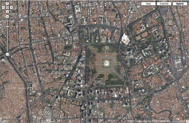
- Monas
- Bunderan HI (Hotel Indonesia, Mandarin Oriental Hotel, Grand Hyatt, Plaza Indonesia)
- Plaza Semangi (still under construction)
- Ancol
- Senayan
- Kelapa Gading Mal
- Jl. Rasuna Said
- Gedung MPR/DPR (parliament building)
3 comments:
This is great! I can even see a swimming pool in back of my house.
wah, macet di gatsu kelihatan banget euy, sepertinya di ambil sore hari nich
good resolution however they're quite old though. I dont see the construction of The Peak, Sudirman Plaza etc. Even Semanggi Plaza looks like still U/C....
Post a Comment